EZG-File: Difference between revisions
m (category rename) |
m (language) |
||
| Line 109: | Line 109: | ||
For the calculation of snow the ''Snow-Compaction Method'' according to {{:Literatur:Knauf_1980|Knauf}} is applied. | For the calculation of snow the ''Snow-Compaction Method'' according to {{:Literatur:Knauf_1980|Knauf}} is applied. | ||
*'''S1''': manual input of the snow constants [Y/N] <br/> | *'''S1''': manual input of the snow constants [Y/N] <br/> | ||
*:(if <code>N</code> or | *:(if <code>N</code> or emtpy, default values will be utilized) | ||
*'''S2''': | *'''S2''': Threshold temperature for the formation of snow [°C] | ||
*'''S3''': | *'''S3''': New-snow density [%] | ||
*'''S4''': | *'''S4''': Threshold density as of which water output begins [%] | ||
*'''S5''': | *'''S5''': Temperature dependent melting rate [mm/(K×d)] | ||
*'''S6''': Insolation and soil warmth dependent melting rate [mm/d] | *'''S6''': Insolation and soil warmth dependent melting rate [mm/d] | ||
Value ranges and | Value ranges and default values: | ||
{| cellpadding="5" cellspacing="0" border="0" class="standard stripes" | {| cellpadding="5" cellspacing="0" border="0" class="standard stripes" | ||
|- | |- | ||
! width="200" | Parameter !! Unit !! | ! width="200" | Parameter !! Unit !! Default value !! {{:Literatur:Knauf_1980|Value range}} | ||
|- | |- | ||
| | | Threshold temperature || align="center" | °C || align="center" | 0 || align="center" | ? | ||
|- | |- | ||
| | | New-snow density || align="center" | % || align="center" | 11 || align="center" | 5 - 20 | ||
|- | |- | ||
| | | Threshold density || align="center" | % || align="center" | 40 || align="center" | 40 - 45 | ||
|- | |- | ||
| | | Temperature dependent melting rate || align="center" | mm/(K×d) || align="center" | 1.8 || align="center" | ? | ||
|- | |- | ||
| Insolation and soil warmth dependent melting rate || align="center" | mm/d || align="center" | 4.2 || align="center" | ? | | Insolation and soil warmth dependent melting rate || align="center" | mm/d || align="center" | 4.2 || align="center" | ? | ||
Revision as of 00:21, 27 May 2022
![]() BlueM.Sim | Download | Application | Theory | Development
BlueM.Sim | Download | Application | Theory | Development
Input files · ALL SYS · FKT KTR · EXT JGG WGG TGG · TAL HYA TRS EIN URB VER RUE BEK EZG FKA · BOA BOD LNZ EFL · DIF
Rural catchment
also refer to Theory: Rural catchment
File
*Einzugsgebiete (*.EZG)
*======================
*|------|-----|------------------------------|--------|------------------|------------------------|---------|-----|----------|-----|----------------------------------------------|--------------|-------------------------------------|--------------|
*| Bez  | KNG |      Gebietskenngroessen     |   N    |   Verdunstung    |       Temperatur       | QBASIS  | PSI | SCS (2)  | BF0 |        Retentionskonstanten                  |  Aufteilung  |           Schneekonstanten          | QSpende      |
*|      |     |   A    VG    Ho    Hu    L   | Datei  |Kng Sum    Datei  |Kng Tem JGG TGG  Datei  | qB  JGG | (1) | CN  VorRg| (3) | R  K(VG)   K1     K2    Int    Bas  nLin Expo| Beta1  Beta2 | R  GrT  NSchD  GrD   RateT   RateSB | MQ           |
*|------|-----|------------------------------|--------|------------------|------------------------|---------|-----|----------|-----|----------------------------------------------|--------------|-------------------------------------|--------------|
*|  -   | 1-4 |  ha     %   muNN  muNN   m   | Nummer |1/2 mm/a   Nummer |1/2 °C   -   -   Nummer |l/sqkm - |  -  |  -   mm  |  %  | -    h      h      h      h      h   J/N  -  |   -      -   | -  °C     %     %   mm/(°d)   mm/d  | m3/(s ha)    |
*|-<-->-|-<->-|<----><----><----><----><---->|<------>|-+-<---->-<------>|-+-<-->-<->-<->-<------>|<--->-<->|<--->|<---><--->|<--->|-+-<---->-<---->-<---->-<---->-<---->--+-<--->|-<---->-<---->|-+-<--->-<--->-<--->-<----->-<----->-|-<---------->-|
 |   A  |  B  |   C     D     E     F     G  |    H   | I    J       K   | L   M   N   O      P   |  Q    R |  S  |  T    U  |  V  |R1   R2     R3     R4     R5     R6   R7   R8 |   B1     B2  |S1   S2    S3    S4     S5      S6   |    Q1        |
*|------|-----|------------------------------|--------|------------------|------------------------|---------|-----|----------|-----|----------------------------------------------|--------------|-------------------------------------|--------------|
Explanations
Versionen:
- A: unique ID (must begin with 'A'!)
- B: calculation type [1-4] (see below). Refers to the pervious areas; the impervious areas are generally calculated with the same methods.
- C: area [ha]
- D: fraction of impervious area [%]
- E: maximum height [müNN]
- F: minimum height [müNN]
- G: longest flow path [m]
Rainfall:
- H: Filenumber of the rainfall file (refer to *.EXT-File)
Evaporation:
- I: calculation type for the evaporation (1 = annual evaporation; 2 = evaporation out of a time series / file)
- J: annual evaporation [mm/a]
- If soil moisture calculation: the sum referring to grassland must be entered,which is internally overprinted with hydrographs according to Brandt[1] and Haude[2][3] and is adjusted to the land use in the individual hydrological response unit.
- K: filenumber of the evaporation time series to be utilized (refer to *.EXT-File)
- only daily values may be listed in the time series because the time series values are always additionally overprinted with a daily pattern! (Bug 1)
Temperature:
- L: calculation type for the temperature (1 = mean value with optional annual/ weekly/ daily pattern; 2 = temperature out of a time series/ file)
- M: mean temperature [°C]
- N, O: number of the annual/ weekly/ daily pattern to be utilized
- P: filenumber of the temperature time series to be utilized (refer to *.EXT-File)
Base flow:
- Q: constant base flow [l/s.km²]
- If soil moisture calculation this value only surves the purpose of calculating the initial reservoir content of the groundwater and interflow reservoirs:
S0,Basis = QB,0 × KBasisS0,Interflow = QB,0 × KInterflow
- R: number of the annual pattern to be utilized to scale the base flow (not used by soil moisture)
Calculation type 1: run-off coefficient method:
- S: run-off coefficient
(0 < ψ ≤ 1)
- [math]\displaystyle{ \psi = \frac{N_{eff} + E_T + h_v}{N} }[/math]
- with:
Neff=effective rainfallET= evaporationhv= initial losses (losses due to wetting and troughs)- also refer to http://de.wikipedia.org/wiki/Abflussbeiwert
Calculation type 2: SCS-Method:
- refer to Theory:SCS-Method
- T: CN-Value
(0 < CN ≤ 100) - U: 21-Day prior rainfall height [mm] (is distributed evenly over 21 days), only relevant for the period before the simulation, during the simulation, the prior rainfall height is continuously simulated.
Calculation type 3: soil moisture calculation:
- refer to Theory: soil moisture calculation
- V: initial soil moisture [% of field capacity] this value is overprinted by the global initial soil moisture specified in the ALL-File.
Calculation type 4: specific discharge:
- Q1: constant specific discharge [m3/(s ha)]
Retention constant:

- R1: manual input of the retention constants as well as the distribution factors [Y/N]
- if No (
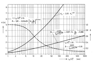
N) the retention constants as well as the distribution factors are calculated internally according to Zaiß[4] on the basis of catchment characteristics. The calculated parameters are written into the Protocol-File,if it's activated.
- if No (
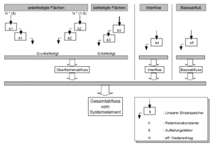
- R2: Retention constant of the impervious area cascade [h]
- R3: Retention constant of the fast cascade [h]
- R4: Retention constant of the slow cascade [h]
- R5: Retention constant of interflow [h] (only for soil moisture calculation)
- R6: Retention constant of base flow [h] (only for soil moisture calculation)
- R7: non-linear calculation [Y/N]
- R8: Exponent fot the non-linear calculation
Distribution factors:
The distribution factors Beta1 and Beta2 only refer to pervious areas!
The sum of Beta1 and Beta2 must be 1 (β1 + β2 = 1)!
- B1: Distribution factor of the fast cascade
0 ≤ β1 ≤ 1 - B2: Distribution factor of the slow cascade
0 ≤ β2 ≤ 1
The distribution factor β3 of the cascade for impervious areas is determined internally on basis of the fraction of impervious areas (D).
- Hint
- Giving Beta2 is optional. If not given it's calculated by
β2 = 1. - β1
Snow constants:
For the calculation of snow the Snow-Compaction Method according to Knauf[5] is applied.
- S1: manual input of the snow constants [Y/N]
- (if
Nor emtpy, default values will be utilized)
- (if
- S2: Threshold temperature for the formation of snow [°C]
- S3: New-snow density [%]
- S4: Threshold density as of which water output begins [%]
- S5: Temperature dependent melting rate [mm/(K×d)]
- S6: Insolation and soil warmth dependent melting rate [mm/d]
Value ranges and default values:
| Parameter | Unit | Default value | Value range[5] |
|---|---|---|---|
| Threshold temperature | °C | 0 | ? |
| New-snow density | % | 11 | 5 - 20 |
| Threshold density | % | 40 | 40 - 45 |
| Temperature dependent melting rate | mm/(K×d) | 1.8 | ? |
| Insolation and soil warmth dependent melting rate | mm/d | 4.2 | ? |
Specific discharge:
constant specific discharge (calculation type = 4)
- Q1: constant specific discharge [m3/(s ha)]
Literature
- ↑ Brandt, T. (1979): Modell zur Abflussgangliniensimulation unter Berücksichtigung des grundwasserbürtigen Abflusses, Technischer Bericht Nr. 24 aus dem Institut für Wasserbau, Fachgebiet Ingenieurhydrologie und Hydraulik der TH Darmstadt
- ↑ Haude, W. (1954): Zur praktischen Bestimmung der aktuellen und potentiellen Evapotranspiration. – Mitteilungen des DWD, Bd. 8; Bad Kissingen
- ↑ Haude, W. (1955): Zur Bestimmung der Verdunstung auf möglichst einfache Weise. Mitteilungen des DWD, 2 (11), Bad Kissingen
- ↑ 4.0 4.1 Zaiß, H. (1986): Abflussermittlung aus Teilflächen, in "Hydrologische Abflussmodelle in der praktischen Anwendung", 36. Fortbildungslehrgang des BWK-Hessen am 21. März 1986, Friedberg [ihwb-Bibliothek: Inv.-Nr. 5593, 10 BWK 36] PDF
 OCR
OCR 
- ↑ 5.0 5.1 Knauf, D. (1980): Die Berechnung des Abflusses aus einer Schneedecke, in: DVWK-Schriften, Heft 46, Analyse und Berechnung oberirdischer Abflüsse PDF

