Soil moisture calculation: Difference between revisions
mNo edit summary |
(→Soil type: language, clarification) |
||
| (37 intermediate revisions by 4 users not shown) | |||
| Line 1: | Line 1: | ||
{{ | {{BlueM.Sim_nav}} | ||
{{BlueMTheory_nav}} | |||
[[Bild:Theorie_Abb39.gif|thumb|600px|center|Abbildung 39: | __TOC__ | ||
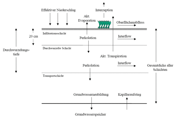
All process-values which are calculated through soil moisture simulation are depicted in the following picture. | |||
[[Bild:Theorie_Abb39.gif|thumb|600px|center|Abbildung 39: calculated process-values through soil moisture simulation]] | |||
== | ==Hydrological Response Units (HRUs)== | ||
[[Bild:Theorie_Abb42.gif|thumb|Abbildung 42: Sectioning of a catchment into HRUs]] | |||
If Runoff is determined through soil moisture simulation, the HRU concept is applied. This results in a catchment being sub-sectioned into a various amount of hydrological homogenous areas. | |||
[[Bild: | [[Bild:Theorie_Abb43.gif|thumb|left|Abbildung 43: Assignment of soil type and land use to a HRU]] | ||
The depicted assignment of land use and soil type is valid for each HRU. The resulting amount of water out of a HRU is applied at the outlet of the elemt. Therefore all HRUs discharge their Water with the same time delay, independent of their position within the catchment. | |||
Soil moisture calculation is computationally intensive and therefore very time-consuming. This is especially true if there are many HRUs in each sub-catchment. | |||
<br clear="all"/> | |||
===Land use=== | |||
Providing information on land use is necessary to run the soil moisture calculation. E.g. the thickness of the rooted zone is determined by providing the root depth in the information regarding land use. Furthermore the parameters of land use are needed to calculate interception and transpiration. The parameters are: | |||
* root depth | |||
* soil coverage | |||
* annual pattern of soil coverage | |||
* leaf area index | |||
* annual pattern of the leaf area index | |||
Providing Haude-Coefficients {{:Literatur:Haude_1954|}}{{:Literatur:Haude_1955|}} is possible by providing an annual pattern and assigning them to the desired land use. This allows for a better consideration of evaporation for each land use. | |||
These Haude-Coefficients scale the valid potential grass reference-evaporation for the time step by their ratio to the corresponding Haude-Coefficient for grass. | |||
===Soil type=== | |||
The soil moisture simulation is based on the non-linear calculation of the individual soil layers. The soil is divided into different soil layers with different soil textures. Each layer is simulated individually and interacts with the layers above or below. The parameters for the soil moisture calculation are the following physical soil properties for the soil textures of each individual layer: | |||
* wilting point (<code>WP</code>) | |||
* field capacity (<code>FK</code>) | |||
* total pore volume (<code>GPV</code>) | |||
* saturated hydraulic-conductivity (<code>k<sub>f</sub>-Wert</code>) | |||
* maximum infiltration capacity (<code>MaxInf</code>) | |||
* maximum rate of capillary rise (<code>MaxKap</code>) | |||
* Assignment to a soil category: sand, silt, clay | |||
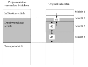
As few as one or as many as six soil layers can be entered. A division into three layers has proven to yield the best results. That is why the entered layers are always transformed into three calculation layers in BlueM internally. | |||
* infiltration layer (standard thickness = 20 [cm]) | |||
* root layer (minimum thickness = 5 [cm]) | |||
* transport layer (minimum thickness = 5 [cm]) | |||
[[Bild:Theorie_Abb38.gif|thumb|300px|Abbildung 38: Example of the aggregation of soil layers for the root layer]] | |||
The new characteristic soil parameters for the internally used layers are calculated by weighting the original parameters of the original layers according to the original thickness of these layers. Saturated hydraulic conductivity is calculated according to conservation of continuity of the flow. For vertical flow the velocity <code>v</code> is to be constant within a layer for a given flow due to the continuity of the flow. Therefore the hydraulic gradient is no longer constant. | |||
:<math>k_{f,v} = \frac{\sum d}{\left ( \frac{d_1}{k_1} + \cdots + \frac{d_i}{k_i} + \cdots + \frac{d_n}{k_n} \right )}</math> | :<math>k_{f,v} = \frac{\sum d}{\left ( \frac{d_1}{k_1} + \cdots + \frac{d_i}{k_i} + \cdots + \frac{d_n}{k_n} \right )}</math> | ||
: | :with | ||
:<code>d<sub>i</sub></code> = | :<code>d<sub>i</sub></code> = depth of each original layer [mm] | ||
:<code>k<sub>i</sub></code> = | :<code>k<sub>i</sub></code> = saturated hydraulic conductivity of each original layer [mm/h] | ||
:<code>k<sub>f,v</sub></code> = | :<code>k<sub>f,v</sub></code> = saturated hydraulic conductivity of the internally used layer [mm/h] | ||
The aggregation of the layers is depicted in [[:Bild:Theorie_Abb38.gif|Abbildung 38]].<br clear="all"/> | |||
== | ==Interception== | ||
In BlueM | In BlueM the inflow to the interception reservoir (<code>Q<sub>zu<sub>IC</sub></sub></code>) is described as a linear function of the free interception reservoir. | ||
:<math>Q_{zu_{ | :<math>Q_{zu_{IC}} = k_{IC} \cdot ( \mbox{IC}_{max} - \mbox{IC}_{akt})</math> | ||
: | :with:<code>k<sub>IC</sub></code> = 10.0 = Parameter to describe the fill rate of the interception reservoir [1/h] (Bug 409) | ||
:<code>k</ | |||
The maximum interception capacity for agricultural crops according to {{:Literatur:Hoyningen-Huene_1983}} is: | |||
:<math> | :<math>\mbox{IC}_{max} = 0.935 + 0.498 \cdot LAI - 0.00575 \cdot LAI^2</math> | ||
: | :with | ||
:<code>LAI</code> | :<code>LAI</code> = Leaf Area Index [-] | ||
The rate of evaporation is assumed to be equal to the rate of potential evaporation (= <code>ET<sub>p</sub></code>). A simple differential equation can be derived due to the fact that inflow is equal to the amount of rain above the vegetation minus the rain which penetrates it : | |||
:<math>\frac{\mbox{ | :<math>\frac{\mbox{dIC}}{\mbox{d}t} = k_{IC} \cdot ( \mbox{IC}_{max} - \mbox{IC}(t)) - ET_p</math> | ||
Therefore the amount of penetrating rain can be determined through the subtraction of interception from rainfall onto the vegetation. | |||
To simplify things it is assumed that this approach is valid for wooded areas, although this approach was derived out of studies for agricultural crops. | |||
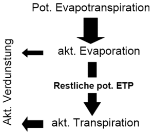
Furthermore the interception evaporation is calculated, which is subtracted from the potential evaporation which leads to a '''reduced potential evaporation''' remaining for the following processes of transpiration and evaporation. | |||
== | ==Soil moisture calculation== | ||
The water balance equation for the soil layer is solved by using a stepwise linear approach for the processes effecting soil moisture, which are '''Infiltration''', '''Evaporation''', '''Transpiration''', '''Percolation''', '''Interflow''' and '''Capillary-Rise'''. The input value for evaporation and transpiration is determined through the reduced potential evaporation due to interception evaporation. | |||
The equation to be solved is as follows: | |||
[[Bild:Theorie_Abb39b.gif|thumb]] | [[Bild:Theorie_Abb39b.gif|thumb]] | ||
| Line 97: | Line 96: | ||
:<math>\frac{d\theta(t)}{d\mbox{t}} = \mbox{Inf}(t) - \mbox{Perk}(t) - \mbox{Eva}_{akt}(t) - \mbox{Trans}_{akt}(t) - \mbox{Int}(t) + \mbox{Kap}(t)</math> | :<math>\frac{d\theta(t)}{d\mbox{t}} = \mbox{Inf}(t) - \mbox{Perk}(t) - \mbox{Eva}_{akt}(t) - \mbox{Trans}_{akt}(t) - \mbox{Int}(t) + \mbox{Kap}(t)</math> | ||
: | :with: | ||
:<code>θ(t)</code> = | :<code>θ(t)</code> = current soil moisture | ||
:<code>Inf(t)</code> = | :<code>Inf(t)</code> = infiltration into the soil | ||
:<code>Perk(t)</code> = | :<code>Perk(t)</code> = percolation | ||
:<code>Eva<sub>akt</sub>(t)</code> = | :<code>Eva<sub>akt</sub>(t)</code> = actual evaporation | ||
:<code>Trans<sub>akt</sub>(t)</code> = | :<code>Trans<sub>akt</sub>(t)</code> = actual transpiration | ||
:<code>Int(t)</code> = | :<code>Int(t)</code> = interflow | ||
:<code>Kap(t)</code> = | :<code>Kap(t)</code> = capillary-rise | ||
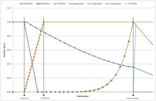
Infiltration, Percolation, Evaporation, Transpiration, Interflow and Capillary-Rise are dependent on the current soil moisture. In the simulation this dependency is described by the following function curves. | |||
[[Bild:Theorie_Abb40.gif|thumb|500px|Abbildung 40: Depiction of selected soil process functions]] | |||
:with: | |||
:<code>k<sub>f</sub></code> = saturated hydraulic conductivity | |||
:<code>nFK</code> = available water capacity (<code>nFK = FK - WP</code>) | |||
:<code>WP</code> = wilting point | |||
:<code>FK</code> = field capacity | |||
:<code>GPV</code> = total pore volume | |||
:<code>I</code> = gradient [-] | |||
:<code>f<sub>PK</sub></code> = soil specific scaling factor for the percolation function | |||
:<code>f<sub>Eva</sub></code> = soil specific scaling factor for the evaporation function | |||
:<code>f<sub>TP</sub></code> = soil specific scaling factor for the transpiration function | |||
:<code>f<sub>1,Int</sub></code> = soil specific scaling factor for the interflow function | |||
:<code>f<sub>2,Int</sub></code> = soil specific scaling factor for the interflow function | |||
:<code>n<sub>Int</sub></code> = soil specific scaling factor for the interflow function | |||
:<code>n<sub>TP</sub></code> = Krümmungsparameter der Transpirationsfunktion | |||
Program parameters are calculated internally. The user only needs to supply the characteristic soil parameters <code>k<sub>f</sub></code>, <code>WP</code>, <code>FK</code> and <code>GPV</code>. | |||
The simulation takes place with a newly developed [[Speicherbaustein|Building-Block]] for the simulation of reservoirs, whichs process function are to be mapped through a stepwise linear approach. | |||
====Infiltration==== | |||
[[Bild:Infiltration.png|thumb|300px|Infiltration function in BlueM in comparison to the function according to {{:Literatur:Holtan_1961|Holtan}} for a sand-soil]] | |||
The original approach according to {{:Literatur:Holtan_1961}}: | |||
:<math>\mbox{Inf}(\theta(t)) = \mbox{a}_v \cdot \left ( \mbox{GPV} - \theta(t) \right )^{1,4} + k_f</math> | :<math>\mbox{Inf}(\theta(t)) = \mbox{a}_v \cdot \left ( \mbox{GPV} - \theta(t) \right )^{1,4} + k_f</math> | ||
: | :with | ||
:<code>a<sub>v</sub></code> = Vegetation parameter (between 0,1 and 1,0) | |||
is used in a modified form in BlueM: | |||
:<math>\mbox{Inf}(\theta(t)) = \begin{cases} \mbox{MaxInf} + k_f, & 0 < \theta(t) < 0,1 \cdot \mbox{nFK} \\ \mbox{MaxInf} \cdot \left( \frac{\mbox{GPV} - \theta(t)}{\mbox{GPV} - 0,1 \cdot \mbox{nFK}} \right) ^{1,4} + k_f, & \theta(t) \ge 0,1 \cdot \mbox{nFK} \end{cases}</math> | |||
it needs to be noted that this function only describes the '''potential Infiltration'''. Actual Infiltration is limited to the available amount of rain. The modification is a results of the consideration that if it rains on a very dry soil the air within the soil cannot escape and thereby limits maximum infiltration. This leads to a stop of exponential increase in contrast to the original approach of Holtan. ("Flowerpot effect") | |||
====Percolation==== | |||
:<math>\ | :<math>\mbox{Perk}(\theta(t)) = \begin{cases} 0, & \theta(t) \le \mbox{f}_{PK} \cdot \mbox{nFK} + \mbox{WP} \\ k_f \cdot \left ( \frac{\theta(t) - \left ( \mbox{f}_{PK} \cdot \mbox{nFK} + \mbox{WP} \right )}{\mbox{GPV} - \left ( \mbox{f}_{PK} \cdot \mbox{nFK} + \mbox{WP} \right )} \right )^{n_{PK}}, & \theta(t) > \mbox{f}_{PK} \cdot \mbox{nFK} + \mbox{WP} \end{cases}</math> | ||
: | :mod. approach according to {{:Literatur:Ostrowski_1992}}, {{:Literatur:Bear_1998}} | ||
:''→ zu modifizieren in [[Talk:Bodenfeuchtesimulation#Perkolation nach van Genuchten|Ansatz nach van Genuchten]]'' | |||
====Interflow==== | |||
Interflow is realtivly independent of soil parameters and depends on soil moisture and slope of the individual HRU. (refer to Bug 28): | |||
:<math>\mbox{Int}(\theta(t)) = \begin{cases} 0, & \theta(t) \le \mbox{f}_{1,Int} \cdot \mbox{nFK} \\ \theta(t)^{\mbox{n}_{Int}} \cdot \frac{I}{\sqrt{1+I^2}}, & \mbox{f}_{1,Int} \cdot \mbox{nFK} < \theta(t) \le \mbox{f}_{2,Int} \cdot \mbox{nFK} \\ \mbox{f}_{2,Int} \cdot \mbox{nFK}, & \theta(t) > \mbox{f}_{2,Int} \cdot \mbox{nFK} \end{cases}</math> | :<math>\mbox{Int}(\theta(t)) = \begin{cases} 0, & \theta(t) \le \mbox{f}_{1,Int} \cdot \mbox{nFK} \\ \theta(t)^{\mbox{n}_{Int}} \cdot \frac{I}{\sqrt{1+I^2}}, & \mbox{f}_{1,Int} \cdot \mbox{nFK} < \theta(t) \le \mbox{f}_{2,Int} \cdot \mbox{nFK} \\ \mbox{f}_{2,Int} \cdot \mbox{nFK}, & \theta(t) > \mbox{f}_{2,Int} \cdot \mbox{nFK} \end{cases}</math> | ||
====Evaporation==== | |||
For the evaporation out of the soil the determined potential evaporation, which was adjusted to land use, is converted into evaporation for fallow land. | |||
:<math>\mbox{Eva}(\theta(t)) = \begin{cases} 0, & \theta(t) \le \mbox{WP} \\ \mbox{f}_{Eva} \cdot \left ( \frac{\theta(t)-\mbox{WP}}{\mbox{GPV}-\mbox{WP}} \right ), & \theta(t) > \mbox{WP} \end{cases}</math> | :<math>\mbox{Eva}(\theta(t)) = \begin{cases} 0, & \theta(t) \le \mbox{WP} \\ \mbox{f}_{Eva} \cdot \left ( \frac{\theta(t)-\mbox{WP}}{\mbox{GPV}-\mbox{WP}} \right ), & \theta(t) > \mbox{WP} \end{cases}</math> | ||
====Transpiration==== | |||
:<math>\mbox{Trans}(\theta(t)) = \begin{cases} 0, & \theta(t) \le \mbox{f}_{TP} \cdot \mbox{nFK} + \mbox{WP} \\ \mbox{f}_{TP} \cdot \left ( \frac{\theta(t) - \mbox{f}_{TP} \cdot \mbox{nFK} + \mbox{WP}}{\mbox{GPV} - \mbox{f}_{TP} \cdot \mbox{nFK} + \mbox{WP}} \right )^{n_{TP}}, & \theta(t) > \mbox{f}_{TP} \cdot \mbox{nFK} + \mbox{WP} \end{cases}</math> | :<math>\mbox{Trans}(\theta(t)) = \begin{cases} 0, & \theta(t) \le \mbox{f}_{TP} \cdot \mbox{nFK} + \mbox{WP} \\ \mbox{f}_{TP} \cdot \left ( \frac{\theta(t) - \mbox{f}_{TP} \cdot \mbox{nFK} + \mbox{WP}}{\mbox{GPV} - \mbox{f}_{TP} \cdot \mbox{nFK} + \mbox{WP}} \right )^{n_{TP}}, & \theta(t) > \mbox{f}_{TP} \cdot \mbox{nFK} + \mbox{WP} \end{cases}</math> | ||
==Literature== | |||
<references/> | <references/> | ||
[[Kategorie:BlueM Theorie]] | [[Kategorie:BlueM Theorie]] | ||
Latest revision as of 02:50, 27 May 2022
![]() BlueM.Sim | Downloads | Application | Theory | Development
BlueM.Sim | Downloads | Application | Theory | Development
BlueM.Sim theory
All process-values which are calculated through soil moisture simulation are depicted in the following picture.
Hydrological Response Units (HRUs)
If Runoff is determined through soil moisture simulation, the HRU concept is applied. This results in a catchment being sub-sectioned into a various amount of hydrological homogenous areas.
The depicted assignment of land use and soil type is valid for each HRU. The resulting amount of water out of a HRU is applied at the outlet of the elemt. Therefore all HRUs discharge their Water with the same time delay, independent of their position within the catchment.
Soil moisture calculation is computationally intensive and therefore very time-consuming. This is especially true if there are many HRUs in each sub-catchment.
Land use
Providing information on land use is necessary to run the soil moisture calculation. E.g. the thickness of the rooted zone is determined by providing the root depth in the information regarding land use. Furthermore the parameters of land use are needed to calculate interception and transpiration. The parameters are:
- root depth
- soil coverage
- annual pattern of soil coverage
- leaf area index
- annual pattern of the leaf area index
Providing Haude-Coefficients [1][2] is possible by providing an annual pattern and assigning them to the desired land use. This allows for a better consideration of evaporation for each land use.
These Haude-Coefficients scale the valid potential grass reference-evaporation for the time step by their ratio to the corresponding Haude-Coefficient for grass.
Soil type
The soil moisture simulation is based on the non-linear calculation of the individual soil layers. The soil is divided into different soil layers with different soil textures. Each layer is simulated individually and interacts with the layers above or below. The parameters for the soil moisture calculation are the following physical soil properties for the soil textures of each individual layer:
- wilting point (
WP) - field capacity (
FK) - total pore volume (
GPV) - saturated hydraulic-conductivity (
kf-Wert) - maximum infiltration capacity (
MaxInf) - maximum rate of capillary rise (
MaxKap) - Assignment to a soil category: sand, silt, clay
As few as one or as many as six soil layers can be entered. A division into three layers has proven to yield the best results. That is why the entered layers are always transformed into three calculation layers in BlueM internally.
- infiltration layer (standard thickness = 20 [cm])
- root layer (minimum thickness = 5 [cm])
- transport layer (minimum thickness = 5 [cm])
The new characteristic soil parameters for the internally used layers are calculated by weighting the original parameters of the original layers according to the original thickness of these layers. Saturated hydraulic conductivity is calculated according to conservation of continuity of the flow. For vertical flow the velocity v is to be constant within a layer for a given flow due to the continuity of the flow. Therefore the hydraulic gradient is no longer constant.
- [math]\displaystyle{ k_{f,v} = \frac{\sum d}{\left ( \frac{d_1}{k_1} + \cdots + \frac{d_i}{k_i} + \cdots + \frac{d_n}{k_n} \right )} }[/math]
- with
di= depth of each original layer [mm]ki= saturated hydraulic conductivity of each original layer [mm/h]kf,v= saturated hydraulic conductivity of the internally used layer [mm/h]
The aggregation of the layers is depicted in Abbildung 38.
Interception
In BlueM the inflow to the interception reservoir (QzuIC) is described as a linear function of the free interception reservoir.
- [math]\displaystyle{ Q_{zu_{IC}} = k_{IC} \cdot ( \mbox{IC}_{max} - \mbox{IC}_{akt}) }[/math]
- with:
kIC= 10.0 = Parameter to describe the fill rate of the interception reservoir [1/h] (Bug 409)
The maximum interception capacity for agricultural crops according to von Hoyningen-Huene (1983)[3] is:
- [math]\displaystyle{ \mbox{IC}_{max} = 0.935 + 0.498 \cdot LAI - 0.00575 \cdot LAI^2 }[/math]
- with
LAI= Leaf Area Index [-]
The rate of evaporation is assumed to be equal to the rate of potential evaporation (= ETp). A simple differential equation can be derived due to the fact that inflow is equal to the amount of rain above the vegetation minus the rain which penetrates it :
- [math]\displaystyle{ \frac{\mbox{dIC}}{\mbox{d}t} = k_{IC} \cdot ( \mbox{IC}_{max} - \mbox{IC}(t)) - ET_p }[/math]
Therefore the amount of penetrating rain can be determined through the subtraction of interception from rainfall onto the vegetation.
To simplify things it is assumed that this approach is valid for wooded areas, although this approach was derived out of studies for agricultural crops.
Furthermore the interception evaporation is calculated, which is subtracted from the potential evaporation which leads to a reduced potential evaporation remaining for the following processes of transpiration and evaporation.
Soil moisture calculation
The water balance equation for the soil layer is solved by using a stepwise linear approach for the processes effecting soil moisture, which are Infiltration, Evaporation, Transpiration, Percolation, Interflow and Capillary-Rise. The input value for evaporation and transpiration is determined through the reduced potential evaporation due to interception evaporation.
The equation to be solved is as follows:
- [math]\displaystyle{ \frac{d\theta(t)}{d\mbox{t}} = \mbox{Inf}(t) - \mbox{Perk}(t) - \mbox{Eva}_{akt}(t) - \mbox{Trans}_{akt}(t) - \mbox{Int}(t) + \mbox{Kap}(t) }[/math]
- with:
θ(t)= current soil moistureInf(t)= infiltration into the soilPerk(t)= percolationEvaakt(t)= actual evaporationTransakt(t)= actual transpirationInt(t)= interflowKap(t)= capillary-rise
Infiltration, Percolation, Evaporation, Transpiration, Interflow and Capillary-Rise are dependent on the current soil moisture. In the simulation this dependency is described by the following function curves.
- with:
kf= saturated hydraulic conductivitynFK= available water capacity (nFK = FK - WP)WP= wilting pointFK= field capacityGPV= total pore volumeI= gradient [-]fPK= soil specific scaling factor for the percolation functionfEva= soil specific scaling factor for the evaporation functionfTP= soil specific scaling factor for the transpiration functionf1,Int= soil specific scaling factor for the interflow functionf2,Int= soil specific scaling factor for the interflow functionnInt= soil specific scaling factor for the interflow functionnTP= Krümmungsparameter der Transpirationsfunktion
Program parameters are calculated internally. The user only needs to supply the characteristic soil parameters kf, WP, FK and GPV.
The simulation takes place with a newly developed Building-Block for the simulation of reservoirs, whichs process function are to be mapped through a stepwise linear approach.
Infiltration
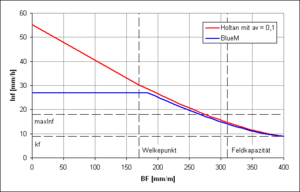
The original approach according to Holtan (1961)[4]:
- [math]\displaystyle{ \mbox{Inf}(\theta(t)) = \mbox{a}_v \cdot \left ( \mbox{GPV} - \theta(t) \right )^{1,4} + k_f }[/math]
- with
av= Vegetation parameter (between 0,1 and 1,0)
is used in a modified form in BlueM:
- [math]\displaystyle{ \mbox{Inf}(\theta(t)) = \begin{cases} \mbox{MaxInf} + k_f, & 0 \lt \theta(t) \lt 0,1 \cdot \mbox{nFK} \\ \mbox{MaxInf} \cdot \left( \frac{\mbox{GPV} - \theta(t)}{\mbox{GPV} - 0,1 \cdot \mbox{nFK}} \right) ^{1,4} + k_f, & \theta(t) \ge 0,1 \cdot \mbox{nFK} \end{cases} }[/math]
it needs to be noted that this function only describes the potential Infiltration. Actual Infiltration is limited to the available amount of rain. The modification is a results of the consideration that if it rains on a very dry soil the air within the soil cannot escape and thereby limits maximum infiltration. This leads to a stop of exponential increase in contrast to the original approach of Holtan. ("Flowerpot effect")
Percolation
- [math]\displaystyle{ \mbox{Perk}(\theta(t)) = \begin{cases} 0, & \theta(t) \le \mbox{f}_{PK} \cdot \mbox{nFK} + \mbox{WP} \\ k_f \cdot \left ( \frac{\theta(t) - \left ( \mbox{f}_{PK} \cdot \mbox{nFK} + \mbox{WP} \right )}{\mbox{GPV} - \left ( \mbox{f}_{PK} \cdot \mbox{nFK} + \mbox{WP} \right )} \right )^{n_{PK}}, & \theta(t) \gt \mbox{f}_{PK} \cdot \mbox{nFK} + \mbox{WP} \end{cases} }[/math]
- → zu modifizieren in Ansatz nach van Genuchten
Interflow
Interflow is realtivly independent of soil parameters and depends on soil moisture and slope of the individual HRU. (refer to Bug 28):
- [math]\displaystyle{ \mbox{Int}(\theta(t)) = \begin{cases} 0, & \theta(t) \le \mbox{f}_{1,Int} \cdot \mbox{nFK} \\ \theta(t)^{\mbox{n}_{Int}} \cdot \frac{I}{\sqrt{1+I^2}}, & \mbox{f}_{1,Int} \cdot \mbox{nFK} \lt \theta(t) \le \mbox{f}_{2,Int} \cdot \mbox{nFK} \\ \mbox{f}_{2,Int} \cdot \mbox{nFK}, & \theta(t) \gt \mbox{f}_{2,Int} \cdot \mbox{nFK} \end{cases} }[/math]
Evaporation
For the evaporation out of the soil the determined potential evaporation, which was adjusted to land use, is converted into evaporation for fallow land.
- [math]\displaystyle{ \mbox{Eva}(\theta(t)) = \begin{cases} 0, & \theta(t) \le \mbox{WP} \\ \mbox{f}_{Eva} \cdot \left ( \frac{\theta(t)-\mbox{WP}}{\mbox{GPV}-\mbox{WP}} \right ), & \theta(t) \gt \mbox{WP} \end{cases} }[/math]
Transpiration
- [math]\displaystyle{ \mbox{Trans}(\theta(t)) = \begin{cases} 0, & \theta(t) \le \mbox{f}_{TP} \cdot \mbox{nFK} + \mbox{WP} \\ \mbox{f}_{TP} \cdot \left ( \frac{\theta(t) - \mbox{f}_{TP} \cdot \mbox{nFK} + \mbox{WP}}{\mbox{GPV} - \mbox{f}_{TP} \cdot \mbox{nFK} + \mbox{WP}} \right )^{n_{TP}}, & \theta(t) \gt \mbox{f}_{TP} \cdot \mbox{nFK} + \mbox{WP} \end{cases} }[/math]
Literature
- ↑ Haude, W. (1954): Zur praktischen Bestimmung der aktuellen und potentiellen Evapotranspiration. – Mitteilungen des DWD, Bd. 8; Bad Kissingen
- ↑ Haude, W. (1955): Zur Bestimmung der Verdunstung auf möglichst einfache Weise. Mitteilungen des DWD, 2 (11), Bad Kissingen
- ↑ von Hoyningen-Huene, J. (1983): Die Interzeption des Niederschlages in landwirtschaftlichen Pflanzenbeständen. DVWK Schriften, Nr. 57, S. 1 - 53, PDF

- ↑ 4.0 4.1 Holtan, H.N. (1961): A Concept for Infiltration Estimates in Watershed Engineering, U.S. Department of Agriculture, Agricultural Research Service, Bulletin 41-51, p. 25
- ↑ Ostrowski, M. (1992): Ein universeller Baustein zur Simulation hydrologischer Prozesse, Wasser und Boden, Heft 11 (PDF
 )
)
- ↑ Bear, J. (1988): Dynamics of fluids in porous media, American Elsevier Environmental Science Series (books.google.com)
